


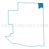
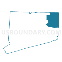
Thompson 4 Voting District, Windham County, Connecticut
About
Outline

Summary
| Unique Area Identifier | 550201 |
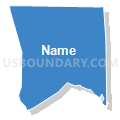
| Name | Thompson 4 Voting District |
| County | Windham County |
| State | Connecticut |
| Area (square miles) | 8.27 |
| Land Area (square miles) | 8.08 |
| Water Area (square miles) | 0.19 |
| % of Land Area | 97.65 |
| % of Water Area | 2.35 |
| Latitude of the Internal Point | 41.99478520 |
| Longtitude of the Internal Point | -71.83309840 |
Maps

Graphs
Select a template below for downloading or customizing gragh for Thompson 4 Voting District, Windham County, Connecticut


Neighbors
Neighoring Voting District (by Name) Neighboring Voting District on the Map
- Douglas Precinct 1, Worcester County, MA
- Thompson 1 Voting District, Windham County, CT
- Thompson 2 Voting District, Windham County, CT
- Webster Precinct 4, Worcester County, MA
- Webster Precinct 5, Worcester County, MA
Top 10 Neighboring County Subdivision (by Population) Neighboring County Subdivision on the Map
- Webster town, Worcester County, MA (16,767)
- Burrillville town, Providence County, RI (15,955)
- Thompson town, Windham County, CT (9,458)
- Douglas town, Worcester County, MA (8,471)
Top 10 Neighboring Unified School District (by Population) Neighboring Unified School District on the Map
- Webster School District, MA (16,767)
- Burrillville School District, RI (15,955)
- Thompson School District, CT (9,458)
- Douglas School District, MA (8,471)
Top 10 Neighboring State Legislative District Lower Chamber (by Population) Neighboring State Legislative District Lower Chamber on the Map
- Eighth Worcester District, MA (43,628)
- State House District 51, CT (24,985)
- State House District 47, RI (13,730)
Top 10 Neighboring State Legislative District Upper Chamber (by Population) Neighboring State Legislative District Upper Chamber on the Map
- Worcester & Norfolk District, MA (173,480)
- State Senate District 29, CT (103,291)
- State Senate District 23, RI (28,574)
Top 10 Neighboring 111th Congressional District (by Population) Neighboring 111th Congressional District on the Map
- Congressional District 2, CT (729,771)
- Congressional District 2, MA (661,045)
- Congressional District 1, RI (519,021)
Top 10 Neighboring Census Tract (by Population) Neighboring Census Tract on the Map
- Census Tract 7521, Worcester County, MA (8,471)
- Census Tract 7541, Worcester County, MA (6,502)
- Census Tract 9001, Windham County, CT (4,570)
- Census Tract 130.01, Providence County, RI (3,479)